
METROLINX
PROJECT MAP
INTERFACE
Metrolinx projects face labour obstacles, project delays, and extra expenses due to their inefficient work block scheduling across internal and external projects. A project map interface will reduce the potential of conflicts arising.
Project Type:
Timeline:
Role:
Work
12 Weeks
Product Owner/Designer
Skills:
User Research
User Interviews and Usability Testing
Business Justification
Business Model
ArcGIS and Google MyMaps
Avoiding Future Problems
The Challenge: Metrolinx provides public transportation to millions of users per day, however the work behind the scenes is more challenging than it seems. Current and future Metrolinx projects, specifically by Union Station where space is limited, have a high potential of conflicting with internal and third party construction, train schedules, and labour availability.
The Goal: Create a mapping interface available for all project management teams, with internal and external projects listed, to organize and manage work scheduling before conflict arises.
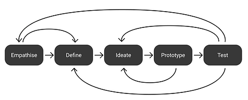
The design thinking approach will be used to complete this project with a focus on prototyping and testing. This project was conducted under the Director and Manager of Union Station Rail & Corridor (USRC) at Metrolinx.
Determining the Business Needs
The project management teams in the USRC department have always faced struggles with project construction. The research began by finding the problems the PM team has been having with their projects and the factors that affect these decisions. Various people and departments were noted to begin research.
User Interviews
Project Managers in each USRC team was interviewed to find common problems faced during the project lifetime. Stakeholders that had influence in these issues were also contacted to determine what features will be beneficial from their end.
-
PM teams and stakeholders listed various factors that create problems for their project include timing, area, labour availability, and scheduling..
-
Users had negative responses regarding the current system of work block scheduling projects had to abide by.
-
Communication between all teams involved took too much time as meetings lasted for hours every week.
Ideation to Prototyping
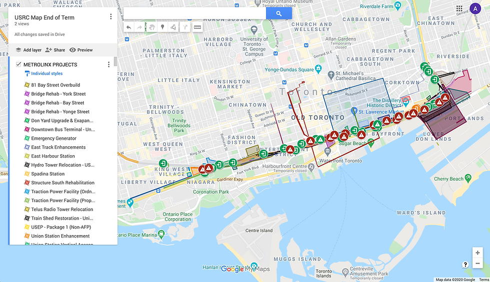
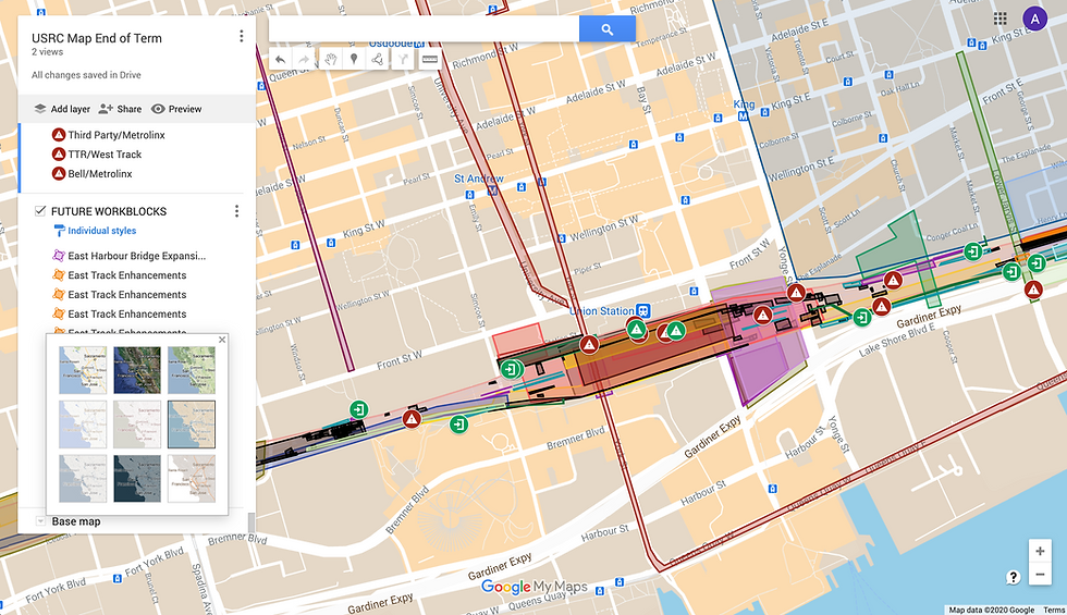
As the idea was still held within the USRC corridor, I decided to proceed with the project map interface using Google MyMaps. All projects in the USRC were created along with third party projects that have been known to interfere with our project work. With as much information as I could gather about relevant projects, the USRC team began to iterate the interface for six weeks.
-
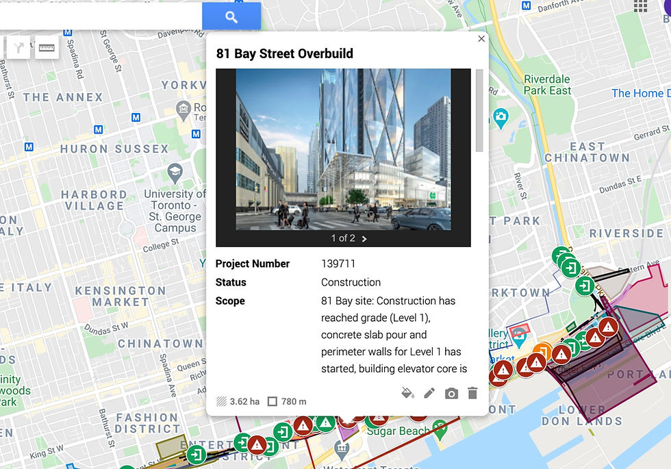
All project title information was determined including scope, project number, work block dates, contact information, and more.
-
Project areas were mapped to observe what projects interfere or may interfere with another given project.
-
Safety routes, fire hazards, and emergency exits were mapped for easy project planning.
Recognizing Innovation
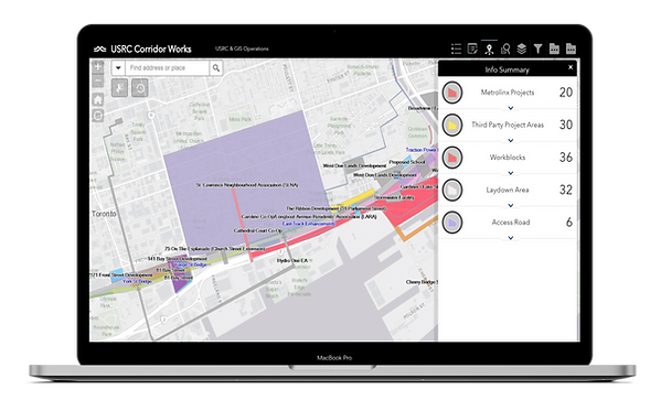
With the innovative ideas coming out of this simple project map interface, news spread across the company with the President of Metrolinx reaching out. After a few discussions with the senior team, funding was set for a team to transfer the Google MyMaps project map interface to an internal ArcGIS online software and further develop the project there. A business justification was created to submit with the funding proposal discussing the current problems and their background information, project requests, and project benefits. I began to work closely with the new ArcGIS online team to create a project map interface that is supported by the previous research and basic design principles. Three iterations of analyzing the new interface took place before I left the position to return to school.
ArcGIS Integration Feedback
-
Users must be able to view all basic information needed in window pop-up (minimize scrolling by reducing line spacing, font size, and hiding empty categories).
-
The user flow to create a new project is too long for an average member of a project team to complete correctly. This will lead to long term problems with project planning.
-
Information Architecture of project map interface should include multiple parts of project scope under a single project.
-
Information sorting is a key feature to improve the user experience as different project teams are looking to find different project information.
-
More UI features are needed to reduce user error (colour coding projects/conflicts, hover interactions, presentation mode, hiding infrequently used ArcGIS buttons).


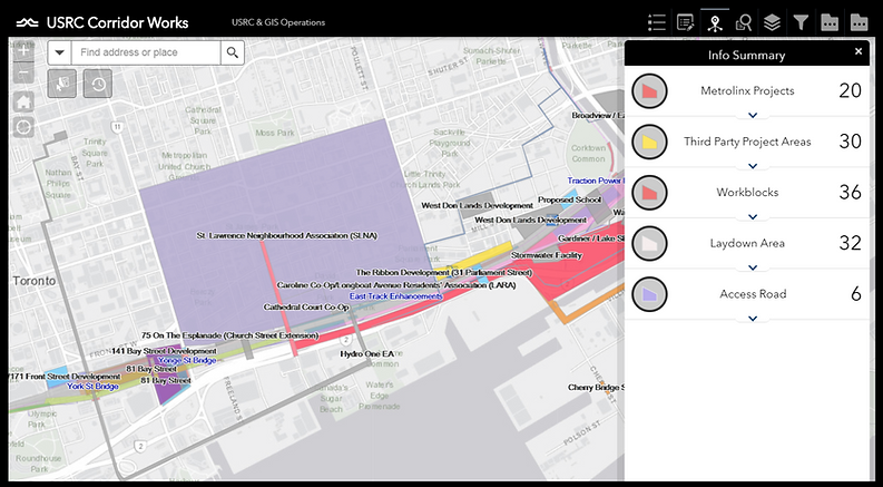
After the 12 weeks working on this project map interface, the development of this interface was fully handed over to the ArcGIS team at Metrolinx. The mapping interface is now being used by multiple Metrolinx departments to assist in scheduling work blocks, project construction, conflict managements, and occupancy of access and storage areas.
Project Learnings
This is the first time I was able to provide the design thinking approach to create a UI interface that will be used on a large scale. When working with different project teams and managers of all levels, I was able to note important lessons to keep in mind.
-
Organization increases communication skills. During feedback iterations, it's important to properly note issues in a simple method, such as a list, for everyone to understand so that the feedback is properly received. Creating a list of the feedback and changes to be made will ensure all requirements are met and that feedback is not being repeated in future meetings because you forgot to address it in the iteration.
-
It's important to show appreciation when providing feedback. We are all trying our best and sometimes we get passionate about our work. Praising work that was completed by others encourages the team to continue and develops a stronger team relationship for easier communication. Gratitude and appreciation go a long way.